
Hurricane Iona Forms in Pacific, No Threat to Hawaii as Storm Tracks West
Quote from Alex Bobby on July 29, 2025, 4:24 AM
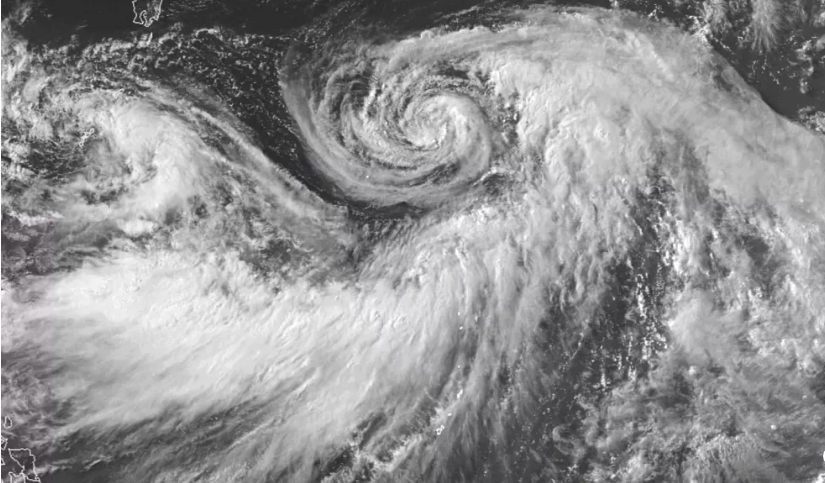
Hurricane Iona Forms in Central Pacific, Poses No Threat to Hawaii
The 2025 hurricane season in the central Pacific has officially begun, with Hurricane Iona becoming the first named storm of the year. According to the U.S. National Hurricane Center in Miami, Iona rapidly intensified from a tropical depression into a full-fledged hurricane on Monday morning. Located about 1,440 kilometres southeast of Honolulu, Iona is currently moving westward over open waters and is not expected to impact the Hawaiian Islands.
Rapid Formation Over Warm Pacific Waters
Iona initially developed as a tropical depression on Sunday, but quickly gathered strength due to favourable conditions, including warm sea surface temperatures and low wind shear. By Monday morning, it had become a hurricane, boasting maximum sustained winds of approximately 120 kilometres per hour and moving west at a steady pace of 17 kilometres per hour.
Despite its strengthening, meteorologists say Iona remains well south of the Hawaiian Islands and poses no immediate threat. The storm is expected to continue on its westward path, staying over open ocean waters and away from populated areas. No coastal watches or warnings have been issued at this time.
Expected Track and Intensity
Forecasters anticipate that Iona will gain more intensity over the next day or two before gradually weakening by the middle of the week. The storm's movement across warm waters may continue to support its strength in the short term, but long-range models suggest a decline as environmental conditions become less favourable.
The National Hurricane Center continues to monitor Iona closely, although confidence remains high that the storm will not veer toward Hawaii or any other Pacific island territories.
Another System in the Region
While Hurricane Iona dominates headlines as the season's first named storm, it is not alone. A second weather system, Tropical Depression Two-C, has also formed in the central Pacific. Located about 1,840 kilometres east-southeast of Honolulu, this depression currently has maximum sustained winds near 55 kilometres per hour and is expected to strengthen in the coming days.
Although this system is still in its early stages, meteorologists are observing it carefully to determine whether it could evolve into the season’s second named storm. For now, like Iona, it does not appear to pose a threat to Hawaii.
Pacific Hurricane Season Outlook
The central Pacific hurricane season typically runs from June through November, with peak activity often occurring between July and September. The formation of Iona and Tropical Depression Two-C marks an active beginning to the season. Experts have forecasted a near-to-above-normal season, driven in part by warmer ocean temperatures associated with climate variability.
For residents of Hawaii and other Pacific island communities, the early appearance of these storms is a reminder to remain prepared, even if current systems pose no danger. Emergency officials advise keeping an eye on official weather updates and having a plan in place in case conditions change.
Keeping Watch Without Panic
Though Hurricane Iona is expected to remain far from land, its rapid formation demonstrates how quickly tropical systems can intensify. Authorities urge the public not to be complacent, even when storms appear distant. Preparedness and vigilance remain key throughout the hurricane season.
In the meantime, travellers and residents across the Hawaiian Islands can breathe a sigh of relief as Iona continues to churn far to the south—impressive in strength, but harmless in trajectory.
Looking Forward
As Hurricane Iona continues its journey westward across the central Pacific, forecasters will keep a close eye on its path and intensity. While the current trajectory keeps it far from Hawaii, the storm’s rapid development serves as an early-season wake-up call. With another tropical depression already forming, the coming weeks could see more activity in the region.
Residents and travellers in the Pacific should stay informed through official weather channels and be ready to act if future systems pose a threat. Although Iona may not bring direct impacts, its arrival marks the beginning of what could be an eventful hurricane season—one that will require both awareness and preparedness as the months unfold.
Final Thought
Hurricane Iona may not pose a danger to land, but its swift formation is a powerful reminder of how quickly tropical systems can evolve. As the 2025 Pacific hurricane season kicks off, early activity like this reinforces the importance of staying informed and prepared. Nature doesn't always follow forecasts, and while Iona heads harmlessly out to sea, it’s a signal that the season is underway—and vigilance is key.
Conclusion:
Hurricane Iona’s formation signals the start of an active Pacific storm season, but with no current threat to land, it serves more as a reminder of nature’s power than an immediate danger. With a second system also forming, the season is off to a swift start—highlighting the need for ongoing preparedness even in the face of distant storms.Meta Description:
Hurricane Iona, the first named storm of the 2025 Pacific hurricane season, has formed southeast of Hawaii but poses no threat to the islands, according to the National Hurricane Center.
Hurricane Iona Forms in Central Pacific, Poses No Threat to Hawaii
The 2025 hurricane season in the central Pacific has officially begun, with Hurricane Iona becoming the first named storm of the year. According to the U.S. National Hurricane Center in Miami, Iona rapidly intensified from a tropical depression into a full-fledged hurricane on Monday morning. Located about 1,440 kilometres southeast of Honolulu, Iona is currently moving westward over open waters and is not expected to impact the Hawaiian Islands.
Rapid Formation Over Warm Pacific Waters
Register for Tekedia Mini-MBA edition 20 (June 8 – Sept 5, 2026).
Register for Tekedia AI in Business Masterclass.
Join Tekedia Capital Syndicate and co-invest in great global startups.
Register for Tekedia AI Lab.
Iona initially developed as a tropical depression on Sunday, but quickly gathered strength due to favourable conditions, including warm sea surface temperatures and low wind shear. By Monday morning, it had become a hurricane, boasting maximum sustained winds of approximately 120 kilometres per hour and moving west at a steady pace of 17 kilometres per hour.
Despite its strengthening, meteorologists say Iona remains well south of the Hawaiian Islands and poses no immediate threat. The storm is expected to continue on its westward path, staying over open ocean waters and away from populated areas. No coastal watches or warnings have been issued at this time.
Expected Track and Intensity

Forecasters anticipate that Iona will gain more intensity over the next day or two before gradually weakening by the middle of the week. The storm's movement across warm waters may continue to support its strength in the short term, but long-range models suggest a decline as environmental conditions become less favourable.
The National Hurricane Center continues to monitor Iona closely, although confidence remains high that the storm will not veer toward Hawaii or any other Pacific island territories.
Another System in the Region

While Hurricane Iona dominates headlines as the season's first named storm, it is not alone. A second weather system, Tropical Depression Two-C, has also formed in the central Pacific. Located about 1,840 kilometres east-southeast of Honolulu, this depression currently has maximum sustained winds near 55 kilometres per hour and is expected to strengthen in the coming days.
Although this system is still in its early stages, meteorologists are observing it carefully to determine whether it could evolve into the season’s second named storm. For now, like Iona, it does not appear to pose a threat to Hawaii.
Pacific Hurricane Season Outlook
The central Pacific hurricane season typically runs from June through November, with peak activity often occurring between July and September. The formation of Iona and Tropical Depression Two-C marks an active beginning to the season. Experts have forecasted a near-to-above-normal season, driven in part by warmer ocean temperatures associated with climate variability.
For residents of Hawaii and other Pacific island communities, the early appearance of these storms is a reminder to remain prepared, even if current systems pose no danger. Emergency officials advise keeping an eye on official weather updates and having a plan in place in case conditions change.
Keeping Watch Without Panic
Though Hurricane Iona is expected to remain far from land, its rapid formation demonstrates how quickly tropical systems can intensify. Authorities urge the public not to be complacent, even when storms appear distant. Preparedness and vigilance remain key throughout the hurricane season.
In the meantime, travellers and residents across the Hawaiian Islands can breathe a sigh of relief as Iona continues to churn far to the south—impressive in strength, but harmless in trajectory.
Looking Forward
As Hurricane Iona continues its journey westward across the central Pacific, forecasters will keep a close eye on its path and intensity. While the current trajectory keeps it far from Hawaii, the storm’s rapid development serves as an early-season wake-up call. With another tropical depression already forming, the coming weeks could see more activity in the region.
Residents and travellers in the Pacific should stay informed through official weather channels and be ready to act if future systems pose a threat. Although Iona may not bring direct impacts, its arrival marks the beginning of what could be an eventful hurricane season—one that will require both awareness and preparedness as the months unfold.
Final Thought
Hurricane Iona may not pose a danger to land, but its swift formation is a powerful reminder of how quickly tropical systems can evolve. As the 2025 Pacific hurricane season kicks off, early activity like this reinforces the importance of staying informed and prepared. Nature doesn't always follow forecasts, and while Iona heads harmlessly out to sea, it’s a signal that the season is underway—and vigilance is key.
Conclusion:
Hurricane Iona’s formation signals the start of an active Pacific storm season, but with no current threat to land, it serves more as a reminder of nature’s power than an immediate danger. With a second system also forming, the season is off to a swift start—highlighting the need for ongoing preparedness even in the face of distant storms.
Meta Description:
Hurricane Iona, the first named storm of the 2025 Pacific hurricane season, has formed southeast of Hawaii but poses no threat to the islands, according to the National Hurricane Center.
Share this:
- Click to share on Facebook (Opens in new window) Facebook
- Click to share on X (Opens in new window) X
- Click to share on WhatsApp (Opens in new window) WhatsApp
- Click to share on LinkedIn (Opens in new window) LinkedIn
- Click to email a link to a friend (Opens in new window) Email
- Click to print (Opens in new window) Print